WELCOME TO SOHEL SHAHIN'S BLOG
Showing posts with label CROP. Show all posts

Tuesday, 27 May 2014

Achieving Good Farm Practice through Improved Soil,Nutrient and Land Managment

http://www.ictinagriculture.org/sites/ictinagriculture.org/files/8285-BX0503_ka.jpg


Good farming practices maximize chances of a good harvest. In the past, conventional farming practices treated entire farms as homogeneous units even though they are often variable in productive potential. This view is changing as technology allows producers to measure soil nutrient status, crop potential, pasture health, and water-use efficiency at specific sites within a field. ICTs like digital soil maps provide extensive soil information that can be stored and accessed online. GPS, satellite imagery, remote sensors, and aerial images help to assess soil and land variations, and mobile applications and the Internet can disseminate the information quickly. 

 Assessing Soil Properties for Climate-Resilient Agriculture 

Accurate soil analyses and improved farming practices are needed urgently because productivity gains are highest in healthy soils and where pesticide, fertilizer, tools, and machinery are used properly. Instruments for mapping and analyzing soil properties have proliferated in the last decade, increasing farmers’ knowledge about the soils on their farms and the need for climate-resilient agricultural practices. The following section discusses these technologies and their associated challenges in broad terms. Subsections discuss innovative technologies specifically related to nitrogen and carbon, two essential chemical components for successful soil conservation and climate change mitigation. 
Digital soil maps are the most promising applications for visualizing soil properties and the gravity of soil nutrient depletion in a particular area.2 The International Working Group on Digital Soil Mapping (WG-DSM) defines digital soil mapping as “the creation and the population of a geographically referenced soil database generated at a given resolution by using field and laboratory observation methods coupled with environmental data through quantitative relationships” (Rossiter 2004). A variety of technologies, including satellite remote sensors and cameras, can be used to survey soil and collect data to create digital soil map      

Remote Sensing Technologies: Raw Data Collection

The first type of ICT that improves productivity includes tools that collect agricultural data:
  • Geographical information systems (GIS) collect geographic data through computer hardware and software to capture, store, update, and display all forms of geographically referenced information by matching coordinates and time to other variables. Data sets formed by GIS constitute “layers” of information (for example, on topography, population size, or agricultural household income) that can be merged and analyzed to establish relationships and produce maps or charts that visualize geographical traits (GIS.com n.d.).
  • Global positioning system (GPS) is a satellite-based positioning and navigation system with three basic components: satellites that orbit the earth, control and monitoring stations on the earth, and the GPS receivers owned by users. GPS receivers pick up signals from the satellites, including precise orbital information (latitude, longitude, and ellipsoidal GPS altitude) of a given object or location, as well as the time. GPSs can function in any weather and are free for public use (GPS.gov n.d.; GARMIN n.d.).
  • Satellite imagery is an image of Earth taken from satellites in orbit. There are four types of satellite imagery: spatial (size of surface area); spectral (wavelength interval); temporal (amount of time); and radiometric (levels of brightness)—which capture a variety of variables about a given area of varying size. The resolution (in meters) of these images depends on the satellite system used and its distance from Earth; weather can interfere mainly with satellite systems utilizing visible wavelengths of light. The cost of the technology depends on the satellite system used, on whether new or archive imagery is purchased, and on possible georeferencing to a coordinate system.
  • Aerial photography and orthophoto mosaic. An aerial photo is an image (once a photograph, now a digital image) of the ground taken from an airplane, helicopter, or radio-controlled aircraft at a given altitude. Aerial images are presented as an orthophoto mosaic that is an alternative to a map. These images are higher in resolution (deci-meter) than satellite images, proving useful for those who want more details of the terrain such as crop conditions or land use. In addition, modern digital aerial photography is georeferenced—that is, each point has geographical coordinates, whereas satellite imagery requires georeferencing to be geographically accurate and compatible with other geographical data (for example, in GIS) (T. Jantunen, personal communication).
  • Laser scanning, or light detection and ranging (LiDAR), is an active airborne sensor using a set of laser beams to measure distance from an aircraft to features on the ground. Airplanes and helicopters can be used for laser scanning. The data from laser scanning are three-dimensional at very high accuracy, and they also allow ground elevation under the tree canopy to be measured. The elevation accuracy of laser scanning data is much better than aerial photography, which makes laser scanning useful for accurate topographic mapping where elevation is critical. The data can also be used to measure forest attributes such as the height and density of trees and thus the volume (aboveground biomass) of the forest(T. Jantunen, personal communication).

Role of ICT in Crop Production

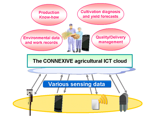
http://www.nec.com/en/global/solutions/nsp/m2m/images/prod-sv1-1.jpgThe rapid advancement in Information and  Communications Technologies (ICTs) has given rise to new applications that were impossible just few years ago. Agriculture is an important sector with the majority of the rural population in developing countries depending on it. The sector faces major challenges of enhancing production in a situation of dwindling natural resources necessary for production. ICT plays an important role in challenging and uplifting the livelihoods of the rural populace using an agro computer-based information system. This paper proposes an   Agro-Information System that enables a farmer to have relevant information about a crop, such as the varieties and other requirements like soil type, temperature, type and quantity of fertilizer, time of planting, time of maturity, planting distance, diseases, pest, pest and Disease control measures, rainfall, sunshine, etc. of that crop. The level of application of this information determines the volume and efficiency of the crop yield. An AIS software is designed and implemented which helps the farmer achieve the afore-mentioned objectives.